Selected Ordovician Outcrops on the Nashville Dome
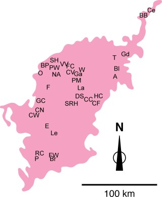
A: Alexandria - Roadcuts along both sides of TN 53 at Smith / Dekalb county line, just north of Alexandria, TN. Alexandria, TN 7.5′ quadrangle. 36° 05′ 03" N, 86° 01′ 49" W.
BB: Big Bottom - Roadcut on east side of TN 53, 1.2 miles south of Clay / Jackson county line and opposite Big Bottom. Burristown, TN 7.5′ quadrangle. 36° 27′ 10" N, 85° 34′ 38" W.
Bl: Bluff Creek - Roadcuts on both sides of TN 53, 2.0 miles north of I-40. Gordonsville, TN 7.5′ quadrangle. 36° 12′ 32" N, 85° 57′ 09" W.
Br: Bradshaw Creek - Composite of 2 outcrops. (1) Roadcut on south side of US 64, 1.1 miles east of intersection with I-65. Frankewing, TN 7.5′ quadrangle. 35° 11′ 24" N, 86° 50′ 59" W. (2) Roadcuts on both sides of US 64 at Lincoln County / Giles County line. Frankewing, TN 7.5′ quadrangle. 35° 11′ 17" N, 86° 49′ 49" W.
BP: Briley Parkway - Roadcut on both sides of eastbound exit ramp #21 from TN 155 (Briley Parkway) at US 41A / Clarksville Pike exit (exit #21), Nashville West, TN 7.5′ quadrangle., 36° 13′ N, 86° 50′ W. Additional roadcut on both sides of TN 155 (Briley Parkway), 0.6 miles northeast of bridge over Eaton Creek and 3.7 miles northeast of bridge over Cumberland River, Nashville West, TN 7.5′ quadrangle., 36° 13′ N, 86° 50′ W.
CF: Carson Fork - Roadcut on south side of US 70S, 0.7 miles east of Carson Fork Creek and 0.5 miles east of intersection with TN 64, Readyville, TN 7.5′ quadrangle., 35° 48′ N, 86° 08′ W.
Ce: Celina - Roacut on north side of TN 53, 0.5 miles east of Obey River bridge and opposite Walker Bend. Dale Hollow Dam, TN-KY 7.5′ quadrangle. 36° 32′ 36" N, 85° 28′ 54" W.
CV: Central Valley - Roadcuts on both east and west sides of I-840 (under construction), just south of intersection with Central Valley Road, near Mona, Tennessee. Walterhill, TN 7.5′ quadrangle. 35° 58′ 14"N, 86° 26′ 43" W.
CN: Columbia North - Roadcut on both sides of US 412 / US 43, 1.2 miles northeast of overpass over TN 50, Columbia or Godwin, TN 7.5′ quadrangle., 35° 37′ N, 87° 05′ W.
CW: Columbia West - Roadcut on both sides of US 412 / US 43, 0.3 miles west of overpass over TN 50, Columbia, TN 7.5′ quadrangle., 35° 37′ N, 87° 06′ W.
CC: Cripple Creek - Streamcut on west bank of Cripple Creek at US 70S bridge, and roadcuts on both sides of US 70S immediately west of Cripple Creek, Dillton, TN 7.5′ quadrangle., 35° 49′ N, 86° 15′ W.
DS: Double Springs - Roadcuts on both sides of US 70S / TN 1, 1.2 miles west of intersection with Mt. Herman Road. Dillton, TN 7.5′ quadrangle. 35° 49′ N, 86° 19′ W.
E: Exit 32 - Roadcuts on west side of southbound onramp and on east side of northbound offramp from I-65 at TN 373 exit (exit #32), Campbells Station, TN 7.5′ quadrangle., 35° 26′ 54" N, 86° 53′ 02" W.
FC: Fall Creek - Composite of 2 outcrops. (1) Roadcuts on both sides of TN 840, 3.2 miles south of Wilson / Rutherford county line. Gladeville, TN 7.5′ quadrangle. 36° 00′ 31" N, 86° 25′ 29" W. (2) Roadcuts on both sides of TN 840, 1.8 miles south of Wilson / Rutherford county line. Gladeville, TN 7.5′ quadrangle. 36° 01′ 43" N, 86° 25′ 47" W.
FW: Frankewing - Composite of 2 outcrops. (1) Roadcuts along southbound onramp from US 64 / TN 15 to I-65 at exit #14. Frankewing, TN 7.5′ quadrangle. 35° 11′ 37" N, 86° 52′ 20" W. (2) Roadcuts along northbound onramp from US 64 / TN 15 to I-65 at exit #14. Frankewing, TN 7.5′ quadrangle. 35° 11′ 35" N, 86° 52′ 12" W.
F: Franklin YMCA - Roadcuts on both sides of US 31, 0.5 miles north of intersection with US 431 and 0.2 miles north of bridge over Harpeth River. Franklin, TN 7.5′ quadrangle. 35° 54′ N, 86° 51′ W.
F: Franklin - Roadcuts on both sides of US 31, 1.2 miles north of intersection with TN 96. Franklin, TN 7.5′ quadrangle. 35° 56′ N, 86° 51′ W.
GC: Garrison Creek - Roadcut on southeast side of Natchez Trace Parkway between mile markers 427 and 428, and 0.1 miles southwest of Garrison Creek picnic area. Theta, TN 7.5′ quadrangle. 35° 52′ 19" N, 87° 02′ 04" W.
Gd: Gladdice - Roadcuts on both sides of TN 85, 1.3 miles northeast of bridge over Salt Lick Creek in Gladdice, Granville, TN 7.5′ quadrangle., 36° 21′ 11" N, 85° 47′ 26" W.
Ga: Gladeville - Composite of 2 outcrops. (1) Roadcuts on both sides of TN 840, 1.0 mile north of TN 265 / Central Pike overpass. Martha, TN 7.5′ quadrangle. 36° 08′ 20" N, 86° 23′ 01" W. (2) Roadcuts on both sides of southbound exit ramp from TN 840 to TN 265 / Central Pike. Martha, TN 7.5′ quadrangle. 36° 07′ 55" N, 86° 23′ 47" W.
HC: Hollis Creek - Roadcuts on both sides of US 70S on east side of Hollis Creek valley, 2.3 miles east of intersection with TN 64, Woodbury, TN 7.5′ quadrangle., 35° 48′ N, 86° 07′ W.
La: Lascassas - Roadcut on northwest side of TN 96, immediately west of intersection with TN 266, Lascassas, TN 7.5′ quadrangle., 35° 55′ 45" N, 86° 17′ 17" W.
Le: Lewisburg - Roadcuts on both sides of TN 417, 0.1 mile southwest of intersection with US 431 / TN 50, Lewisburg, TN 7.5′ quadrangle., 35° 28′ 22" N, 86° 48′ 06" W.
NA: Nashville Airport - Roadcuts along both sides of northbound offramp from Donelson Pike (TN 255) to Nashville International Airport, Antioch, TN 7.5′ quadrangle., 36° 07′ N, 86° 40′ W.
O: Old Hickory Boulevard - Roadcut primarily on east side of Old Hickory Boulevard (TN 251), approximately 1.3 miles north of intersection with US70S / TN 1 (Memphis-Bristol Highway). 36° 05′ 34" N, 86° 55′ 23" W.
PW: Peyton’s Warehouse - Small quarry at Peyton’s Warehouse at end of and north of Kaspar Way. Goodlettsville, TN 7.5′ quadrangle. 36° 20′ 52" N, 86° 43′ 06" W.
PM: Pierce’s Mill - Streamcut on north bank of Stones River just below dam at Pierce’s Mill, 0.1 miles east of US 231 / TN 10 bridge over Stones River, Walterhill, TN 7.5′ quadrangle., 35° 56′ 32" N, 86° 22′ 40" W.
P: Pulaski - Composite of 3 outcrops. (1) Roadcut on south side of US 64 bypass, 1.7 miles east of intersection with US 31 on south side of Pulaski. Tarpley, TN 7.5′ quadrangle. 35° 10′ 33" N, 86° 59′ 17" W. (2) Roadcut on small service road immediately south of and parallel to US 64 bypass, 1.5 miles east of intersection with US 31 on south side of Pulaski. Tarpley, TN 7.5′ quadrangle. 35° 10′ 26" N, 86° 59′ 26" W. (3) Roadcut on south side of US 64 bypass, 0.1 miles east of intersection with TN 166 on south side of Pulaski. Pulaski, TN 7.5′ quadrangle. 35° 10′ 09" N, 87° 02′ 58" W.
RC: Richland Creek - Roadcut on north side of US 64 bypass, 0.7 miles east of intersection with TN 166 and 1.5 miles west of intersection with US 31 on south side of Pulaski. Pulaski, TN 7.5′ quadrangle. 35° 10′ 02" N, 87° 02′ 26" W.
SRH: Sam Ridley Highway - Roadcuts on both sides of TN 266 (Sam Ridley Highway), 0.7 miles southwest of intersection with Old Nashville Pike. Smyrna, TN 7.5′ quadrangle. 35° 58′ 50" N, 86° 33′ 32" W.
SH: Springfield Highway - Roadcut on both sides of US 41, 1 mile northwest of Sumner/Davidson county line. Goodlettsville, TN 7.5′ quadrangle. 36° 22′ N, 86° 43′ W.
T: Tanglewood - Roadcut on northeast side of TN 25 along Petty Bluff, 0.5 miles northwest of intersection with TN 80. Carthage, TN 7.5′ quadrangle. 36° 17′ 35" N, 85° 59′ 50" W.
VV: Vietnam Vets Highway - Series of roadcuts on both sides of exit ramp from TN 386 (Vietnam Veterans Parkway) onto US 31E. Goodlettsville, TN 7.5′ quadrangle. 36° 18′ N, 86° 39′ W. Additional roadcuts just west and just east of exit ramp along TN 386. Lowest part of the section exposed at roadcut on southbound exit ramp for Conference Drive from westbound TN 386 (Vietnam Veterans Parkway), Goodlettsville, TN 7.5′ quadrangle., 36° 18′ N, 86° 40′ W.
W: Whip-poor-will Road - Roadcuts on both sides of US 231 / TN 10, 0.1 miles north of Whip-poor-will Road in Vine, TN. Vine, TN 7.5′ quadrangle. 36° 02′ 36" N, 86° 21′ 10" W.
