Selected Upper Ordovician Outcrops on The Cincinnati Arch
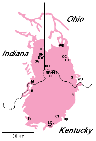
AC: Ashlock Cemetary - Roadcuts on U.S. Route 27, 0.8 miles south of Garrard / Lincoln County Line. Lancaster, KY quadrangle.
37.57361° N, 84.61361° W.
Tate (C2 peritidal), Gilbert (C3 lagoonal), and Bellevue (C3 shallow subtidal) exposed.
B: Bedford - Roadcuts on U.S. Route 42, 2.5 miles east of intersection with U.S. Route 421 in Bedford, Kentucky. Bedford, KY quadrangle.
38.60222° N, 85.27361° W.
Bellevue (C2 shallow subtidal), C3 grainstone shoals, Mount Auburn (C3 shallow subtidal), C4 grainstone shoals, "Sunset" (C4 deep subtidal), Oregonia (C4 shallow subtidal), Rowland (C4 peritidal), Marble Hill Bed (C5), Liberty (C5 deep subtidal), and Saluda (C5 peritidal) exposed.
BR: Blue Rock Road - Roadcuts on Blue Rock Road, 0.1 mile north of intersection with Cross County Highway (Ronald Reagan Highway) and 0.3 miles southeast of intersection with Interstate 275. Cincinnati West, OH quadrangle.
39.22972° N, 84.62112° W.
Mount Auburn (C3 shallow subtidal) and "Sunset" (C4 deep subtidal) exposed.
BW: Bon Well Hill - Roadcut at the intersection of Indiana State Route 101 and Brookville Dam Road, 1 mile north of Brookville, Indiana. Whitcomb (formerly Mount Carmel), IN quadrangle.
39.43693° N, 84.99300° W.
Oregonia (C4 shallow subtidal) and Waynesville (C5 offshore) exposed.
BN: Brookville North - Two roadcuts on opposite sides of valley along Indiana State Route 101, 5.0 miles north of Brookville, Indiana. Whitcomb, IN quadrangle.
39.48750° N, 84.94861° W.
Waynesville (C5 offshore), Liberty (C5 deep subtidal), Lower Whitewater (C5 shallow subtidal), Saluda (C6 lagoonal), and Upper Whitewater (C6 shallow subtidal) exposed.
By: Bybee - Roadcuts on Kentucky State Route 52, just east of Bybee, Kentucky. Panola, KY quadrangle.
37.72322° N, 84.10935° W.
Rowland (C4 peritidal) and Saluda (C5 peritidal) exposed.
CC: Caesar Creek Spillway and Dam - Exposures in emergency spillway of Caesar Creek Lake on Clarksville Road. Oregonia, OH quadrangle.
39.47983° N, 84.05754° W.
Waynesville (C5 offshore), Liberty (C5 deep subtidal) and Whitewater (C5 shallow subtidal) exposed. Hillside exposures on north side of tailwater area at Caesar Creek Dam. Oregonia, OH quadrangle.
39.48471° N, 84.06344° W.
Oregonia (C4 shallow subtidal) and Waynesville (C5 offshore) exposed.
CF: Clays Ferry - Roadcuts on south side of Kentucky State Route 2328 underneath south end of Interstate 75 bridge over Kentucky River. Ford, KY quadrangle.
37.88102° N, 84.33972° W.
Lexington Limestone (M6), Clays Ferry (C1 deep subtidal), Garrard (C2 peritidal), and Fairview (C2 deep subtidal) exposed.
CL: Cowan Lake - Exposures in spillway of Cowan Lake and on north bank of Cowan Lake, adjacent to spillway. Clarksville, OH quadrangle.
39.38945° N, 83.92722° W.
Liberty (C5 deep subtidal) and Lower Whitewater (C5 shallow subtidal) exposed.
Fl: Flemingsburg - Roadcuts along Kentucky State Route 32, 1.1 mile south of Kentucky State Route 11. Flemingsburg, KY quadrangle.
38.40374° N, 83.72613° W.
Mount Auburn (C3 shallow subtidal), C4 grainstone shoal, Oregonia (C4 shallow subtidal), Whitewater (C5 shallow subtidal) exposed.
Fr: Fredericktown - Roadcut on south side of U.S. Route 150, 0.5 miles west of Nelson / Washington county line. Maud, KY quadrangle.
37.76917° N, 85.35694° W.
Bellevue (C2 shallow subtidal; = Calloway Creek), Tate (C2 peritidal), C3 grainstone shoal, Gilbert (C3 lagoonal), Mount Auburn (C3 lagoonal; = Stingy Creek), C4 grainstone shoal, Oregonia (C4 shallow subtidal; = Reba), Rowland (C4 peritidal), Whitewater (C5 shallow subtidal), and Saluda (C5 peritidal) exposed.
G: Georgetown - Roadcuts along Ohio State Route 125 on both sides of Whiteoak Creek valley, 0.8 miles west of intersection with U.S. Route 68 in Georgetown, Ohio. Higginsport, OH quadrangle.
38.87222° N, 83.91667° W.
Fairview (C2 deep subtidal), Bellevue (C2 shallow subtidal), and Corryville (C3 deep subtidal) exposed.
445: K445 - Composite outcrop consists of four sections: K445, CON1, CON2, and CON3. Kope (C1 offshore) and Fairview (C2 deep subtidal) exposed.
K445: Roadcut on both sides of Kentucky State Route 445, 0.2 km west of intersection with Kentucky State Route 8, immediately northwest of the I-275 bridge over the Ohio River near Old Coney Amusement Park. Newport, KY-OH 7 1/2' quadrangle. 39.05611° N, 84.43611° W.
CON1: First roadcut on northwest side of westbound I-275, 0.5 km southwest of intersection of I-275 and the Kentucky bank of Ohio River near Old Coney Amusement Park. Newport, KY-OH 7 1/2' quadrangle. 39.05416° N, 84.43889° W.
CON2: Second roadcut on northwest side of westbound I-275, 0.6 km southwest of intersection of I-275 and the Kentucky bank of Ohio River near Old Coney Amusement Park. Newport, KY-OH 7 1/2' quadrangle. 39.05361° N, 84.44000° W.
CON3: Third roadcut on northwest side of westbound I-275, 0.8 km southwest of intersection of I-275 and the Kentucky bank of Ohio River near Old Coney Amusement Park. Newport, KY-OH 7 1/2' quadrangle. 39.05278° N, 84.44167° W.
LCL: Lincoln County Line - Roadcuts on U.S. Route 27, 0.5 miles south of Garrard / Lincoln county line and 3.5 miles south of Lancaster, Kentucky. Lancaster, KY quadrangle.
37.57778° N, 84.61000° W.
Terrill (C3 peritidal), Sunset (C4 lagoonal), and Oregonia (C4 shallow subtidal; = Reba) exposed.
M: Madison - Roadcut on east side of U.S. Route 421, 0.9 miles north of intersection with Indiana State Route 56 in Madison, Indiana. Madison West, IN-KY quadrangle.
38.74944° N, 85.37639° W.
Mount Auburn (C3 shallow subtidal), "Sunset" (C4 deep subtidal), Oregonia (C4 shallow subtidal), and Liberty (C5 deep subtidal) exposed. Additional roadcut on east side of U.S. Route 421, 3.1 miles north of intersection with Indiana State Route 56 in Madison, Indian. Madison West, IN-KY quadrangle.
38.77750° N, 85.36472° W.
Lower Whitewater (C5 shallow subtidal), Saluda (C5 peritidal), Hitz Bed (C6 lagoonal), and Upper Whitewater (C6 shallow subtidal) exposed.
O: Orphanage Road - Roadcut on north side of Kentucky State Route 371 (Orphanage Road), 0.6 miles west of intersection with Kentucky State Route 17. Newport, KY-OH quadrangle.
39.02972° N, 84.54166° W.
Kope (C1 offshore) exposed.
R: Richmond - Roadcuts on U.S. Route 27, 0.8 miles north of Beelor Road and 1.0 miles south of Richmond, Indiana. Richmond, IN quadrangle.
39.78722° N, 84.90166° W.
Upper Whitewater (C6 shallow subtidal) exposed.
RR: Riedlin Road - Roadcuts on Riedlin (Mason) Road at intersection with Kentucky State Route 16, 0.4 miles north of intersection of interstate 275. Covington, KY-OH quadrangle.
39.02778° N, 84.51056° W.
Kope (C1 offshore), Fairview (C2 deep subtidal) and Bellevue (C2 shallow subtidal) exposed.
SG: South Gate Hill - Roadcuts on Indiana State Route 1, 1.9 miles south of its intersection with U.S. Route 52 at Cedar Grove, Indiana. Cedar Grove, IN quadrangle.
39.33900° N, 84.95286° W.
Oregonia (C4 shallow subtidal), Waynesville (C5 offshore), Liberty (C5 deep subtidal), Lower Whitewater (C5 shallow subtidal), and Saluda (C6 lagoonal) exposed.
WB: Wright Brothers Memorial - Railroad cut on north border of Wright Brothers Memorial Park. Fairborn, OH quadrangle.
39.79611° N, 84.08694° W.
Lower Whitewater (C5 shallow subtidal), C6 grainstone shoal, and Preachersville (C6 peritidal) exposed.
WU: West Union - Roadcut on west side of Ohio State Route 41, 3.2 miles from intersection with Ohio State Route 247 in West Union, Ohio. West Union, OH quadrangle.
38.82722° N, 83.50555° W.
Whitewater (C5 shallow subtidal), Preachersville (C5 peritidal), and Silurian exposed.
