Lithostratigraphic Systems
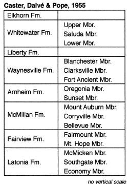
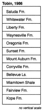
Traditional / Tobin system. The traditional system is reflected in the Caster, Dalvé, and Pope (1955) guidebook. This "traditional" system actually reflects one stage in almost a hundred years of work on Cincinnatian stratigraphic nomenclature, which is summarized by Weiss and Norman (1960). For details of the traditional system, in particular fossil distributions, see the charts for the Eden-Maysville and Richmond.
Tobin (1986) revised much of this traditional nomenclature under purely lithologic criteria, in keeping with the stratigraphic code. Tobin's work follows on that of Ford (1967), who revised the Fairview and Bellevue Formations in terms of the modern stratigraphic code. One unit that both recognize, but that was not part of the traditional nomenclature, is the Miamitown Shale, a shale rich unit near the Fairview-Bellevue contact that pinches out to the southeast in northern Kentucky.
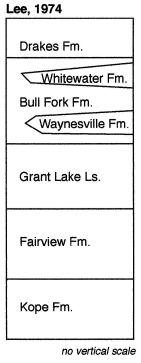
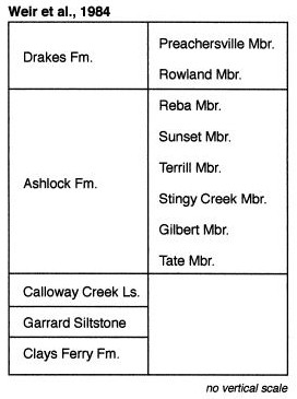
U.S.G.S. / Kentucky Survey system. The Kentucky Geological Survey and the U.S.G.S. began in the 1960's an ambitious mapping program of the entire state of Kentucky at the quadrangle scale. During the course of this mapping, these two surveys revised much of the lithostratigraphic nomenclature of the state. Two systems are used, which reflect the facies changes that occur between the depositionally updip region of south-central Kentucky and the depositionally downdip region of northern Kentucky. The Lee (1974) system (his master's thesis at Miami University) covers northern Kentucky and the Weir et al. (1984) system covers south-central Kentucky. As a matter of convenience, the change in nomenclature is handled on many maps as a vertical cutoff between the two systems. The two systems are not mutually exclusive; local nomenclature may follow some combination of the two.
The Lee (1974) and Weir et al. (1984) systems use several units that are coarse lumpings of many different facies, often spanning multiple depositional sequences (and therefore unconformities). The Grant Lake Formation is essentially equivalent to the traditional McMillan and Arnheim Formations and reflects the fact the members of these traditional formations become increasingly lithologically similar southward into Kentucky. The Bull Fork Formation includes most of the traditional Richmond Group. The Ashlock Formation spans many of the thin, but lithologically distinct members in south-central Kentucky. It is defined in different ways at different places, so its meaning in terms of facies and depositional sequences is not constant.
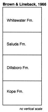
Indiana Survey system. This system is typified by the nomenclature of Brown and Lineback (1966). Of all the systems, this one achieves the greatest amount of lumping of dissimilar facies and depositional sequences. The Kope Formation is nearly equivalent to the traditional Latonia (Eden) Shale. The Dillsboro Formation is an enormous stratigraphic unit, spanning most of the traditional Fairview Formation through Lower Member of the Whitewater Formation. As such it, it includes the C2 through C5 sequences, and offshore, deep subtidal, and shallow subtidal facies. The Saluda Formation includes both peritidal facies of the C5 sequence and lagoonal facies of the C6 sequence. The Whitewater Formation is equivalent to the traditional Upper Member of the Whitewater Formation and the Elkhorn Formation.
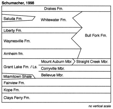
Ohio Survey system. This system reflects the influence of Rick Tobin's views on Cincinnatian stratigraphy and includes many similar elements to Tobin's system. Departures include the recognition of the Bull Fork Formation on the southeastern side of the exposure area in Ohio, the Grant Lake Formation, and the Drakes Formation for the succession of redbeds at the top of the Cincinnatian Series. The Straight Creek Member is a more limestone-dominated lateral equivalent to the Mount Auburn Member.
